

Paisley Town
Details
Accessibility
Brief description
https://en.wikipedia.org/wiki/Paisley,_Renfrewshire


 Cathedral
https://en.wikipedia.org/wiki/Paisley,_Renfrewshire#Landmarks
2025: "Paisley (/ˈpeɪzli/ PAYZ-lee; Scots: Paisley; Scottish Gaelic: Pàislig [ˈpʰaːʃlɪkʲ]) is a large town situated in the west central Lowlands of Scotland. Located north of the Gleniffer Braes and immediately west of Glasgow, it straddles the banks of the White Cart Water, a tributary of the River Clyde. It serves as the administrative centre for the Renfrewshire council area, and is the largest town in the historic county of the same name. It is often cited as "Scotland's largest town" and is the fifth largest settlement in the country, although it does not have city status.
The town became prominent in the 12th century, with the establishment of Paisley Abbey, an important religious hub which formerly had control over other local churches. Paisley expanded significantly during the Industrial Revolution as a result of its location beside White Cart Water, with access to the Clyde and nearby ore, mineral and agricultural resources. Factories and mills developed leading to an increase in the town's population. The town's associations with political radicalism were highlighted by its involvement in the Radical War of 1820, with striking weavers being instrumental in the protests.
By the late 19th century, Paisley was a global centre of the weaving industry, giving its name to the Paisley shawl and the Paisley pattern. However, industrial decline followed in the 20th century. By 1993, all of Paisley's mills had closed, although they are memorialised in the town's museums and civic history.[2] The town now functions as a regional centre for local governance and services as well as a residential commuting area within the Greater Glasgow urban region. "
Address
Royal Alexandra Hospital
Corsebar Road
Paisley
PA2 9PN
+ Paisley Museum
High Street
Paisley
PA1 2BA
+ Paisley Art Institute
Oakshaw Street East
Paisley
PA1 2DD
+ Coats Observatory
49 Oakshaw Street West
Paisley
PA1 2DE
+ Anchor Mill Medical Practice
4 Saucel Crescent
Paisley
PA1 1UB
+ St Mirin's RC Cathedral Paisley https://stmirinscathedral.co.uk/
Cathedral Precincts
Incle Street
Paisley PA1 1HR
Phone
Website
https://en.wikipedia.org/wiki/Paisley,_Renfrewshire#
Directions
Opening Times
Always check with the venue directly for up-to-date information including opening times and admission charges as they may be subject to change
Transport
2025: https://en.wikipedia.org/wiki/Paisley,_Renfrewshire#Transport
" Paisley is connected to the motorway network and the National Rail network, and contains Glasgow Airport within its boundaries.
Paisley is connected by road to the UK motorway network, with the M8 running along the northern edge of the town, Junctions 27, 28 and 29 providing access to Greenock to the west and Glasgow to the east. This forms part of the unsigned E05 Euroroute from Greenock to Gibraltar. Many major A roads converge through the town, including the A726, A737 and A761. The Strathclyde Partnership for Transport, a public body, has direct operational responsibilities covering the area, such as supporting (and in some cases running) local bus services in Paisley (Graham's Bus Service) and across Strathclyde.[101]
The town has four railway stations and is linked by rail to Glasgow city centre as well as Inverclyde and the Ayrshire coast. Paisley Gilmour Street is the largest of the stations and is also the fourth busiest train station in Scotland.[102] There are also smaller stations at Paisley St James, Paisley Canal and Hawkhead. The rail links also connect to Glasgow Prestwick International Airport and ferry routes to Dunoon, the Isle of Arran, Isle of Bute and Northern Ireland. Over the years there have been thirteen railway stations in Paisley and three rail lines that are now closed (The Paisley and Barrhead District Railway,[103] the Barrhead Branch[103] of the GSWR, and the Paisley and Renfrew Railway).[104] Paisley Canal station and the Paisley Canal Line owe their names to the Glasgow, Paisley and Johnstone Canal which occupied the route of the line until 1885, when it was filled in. The line reusues part of the Paisley Canal, which was the site of the Paisley canal disaster in 1810.
Glasgow Airport, operated by AGS Airports, is Scotland's largest airport, located to the north of Paisley at Abbotsinch. It is adjacent to the M8 motorway and served by buses from Paisley Gilmour Street railway station. The planned Glasgow Airport Rail Link project, which was to run through Paisley, was abandoned in 2009. As mentioned above, Glasgow Prestwick Airport in Ayrshire is directly accessible by rail from Paisley Gilmour Street station."
Amenities
https://en.wikipedia.org/wiki/Paisley,_Renfrewshire#Landmarks
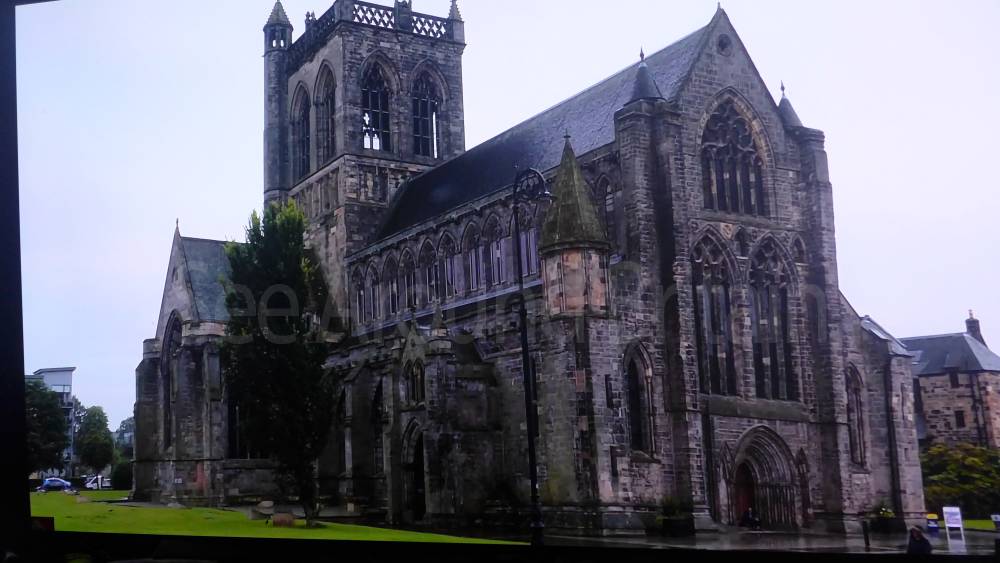
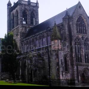
2025: "Most noticeable among the buildings of Paisley is its medieval Abbey in the centre of the town dating from the 12th century. The earliest surviving architecture is the south-east doorway in the nave from the cloister, which has a round arched doorway typical of Romanesque architecture which was the prevalent architectural style before the adoption of Gothic.[citation needed] The choir (east end) and tower date from the late 19th and early 20th centuries and are examples of Gothic Revival architecture. They were reconstructed in three main phases of restorations with the tower and choir conforming to the designs of Dr Peter MacGregor Chalmers. The roof in the nave is the most recent of restorations with the plaster ceiling by Rev Dr Boog which was added in the 1790s being replaced by a timber roof in 1981.[citation needed]
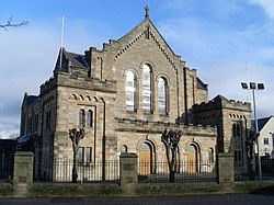
Former Thomas Coats Memorial Baptist Church, named for the industrialist Thomas Coats (1809–1883), is an example of Gothic Revival architecture. It dominates the town's skyline with its crown spire more than 60 m (197 ft) high. Opened in 1894 and designed by Hippolyte Jean Blanc[93] it was the largest Baptist church in Europe. The exterior is made of old red sandstone. Inside, the church is decorated with wood carvings, mosaic floors and marble fonts. The church also contains a 3040 pipe Hill Organ.
The St Mirin's Cathedral in Incle Street is the seat of the Catholic Bishop of Paisley. The church was completed in 1931 to replace an earlier building, in nearby East Buchanan Street, which dated from 1808. The original St Mirin's church was the first Catholic church to be built in Scotland since the Reformation. With the erection of the Diocese of Paisley in 1947 the church was raised to cathedral status.
St Matthew's Church (Church of the Nazarene) at the junction of Gordon Street and Johnston Street is Art Nouveau in style. Designed by local architect William Daniel McLennan, a contemporary of Charles Rennie Mackintosh, it was built in 1905–07.
Other Christian communities have a number of churches in Paisley, many of which were the result of the Industrial Revolution where people from around the British Isles came to Paisley for work.[108] The Roman Catholic Diocese of Paisley, created in 1947, is centred upon the town's St Mirin's Cathedral, the seat of the Bishop of Paisley. Paisley also forms part of the Episcopalian (Anglican) Diocese of Glasgow and Galloway with its main facilities being contained at the Holy Trinity and St Barnabas Church in the town centre, a congregation which united in 2004.[109] There are currently two Baptist congregations in Paisley: in addition to Thomas Coats Memorial Baptist Church (see under "Landmarks – religious sites") is Central Baptist Church, which meets in nearby Lady Lane. Paisley is home to a meetinghouse of the Church of Jesus Christ of Latter-day Saints located on Glenburn Road.
Other smaller religious groups exist in the town. The Methodist Church of Great Britain has a church and central hall opposite Paisley Abbey which forms part of the Ayrshire and Renfrewshire Circuit.[110] The Christadelphians meet in a hall on Alice Street.[111]"
Travel Information
For further travel information in Scotland please see: www.travelinescotland.com
Or call Traveline Scotland on 0871 200 22 33
(Calls cost 12p per minute plus your phone company's access charge)
Location
Nearest Venues

Royal Alexandra Hospital, Paisley
35 metres*
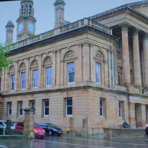
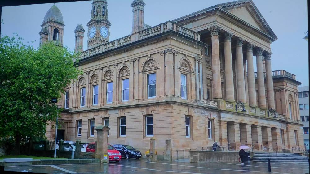
Paisley Town Hall, Abbey Close, Paisley PA1 1JF
1,447 metres*
2.30 miles*
*Distances are calculated in a straight line from the current venue, please allow extra time/distance based on available paths or roads.